
Background:
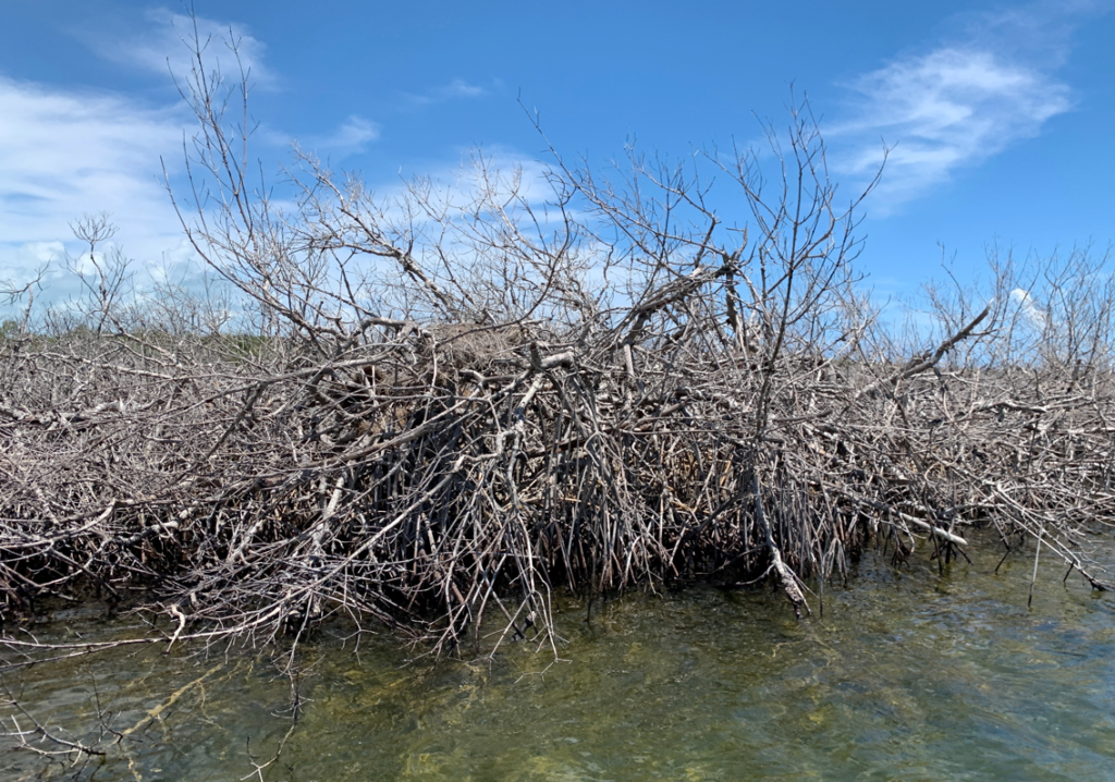
Hurricane Dorian had devastating impact to Grand Bahama and Abaco Islands (Bahamas) in 2021, affecting tens of thousands of people, with hundreds of lives lost and billions of dollars in economic impacts. It is unclear however, how natural ecosystems, including mangroves were affected by the storm (extreme winds, inundation by storm surge and powerful waves) (Figure 1).
An unpublished report using NDVI (Normalized Difference Vegetation Index) values calculated from 10 m resolution satellite imagery indicated that 73.8% of mangrove systems of Grand Bahama and 40.1% of Abaco’s mangroves were “Damaged or Destroyed” by hurricane Dorian (Steinberg, Cissel and Lewis, 2020). While this information may be useful to determine the broad-scale areas affected by Dorian, it was of limited utility to guide restoration efforts due to the coarse spatial resolution.
Furthermore, there was little to no information from local stakeholders as to where they believed
mangroves were impacted and should be restored. Finally, assessments based on satellite imagery alone could not provide information on whether Dorian changed of the function or value of mangrove ecosystems, such as their role as fish habitat. Further study was required to address these gaps to help natural resource managers and other stakeholders about whether a site will make a natural recovery, requires intervention to assist with recovery, or what that intervention should be.
Objectives :
In order to address these gaps of information, the objective of this pilot project was to assess and prioritise restoration for mangrove systems of Abaco and Grand Bahama islands which were most affected by Hurricane Dorian as well as implement restoration efforts in identified sites with best restoration practices
The Perry Institute for Marine Science (PIMS) implemented the project between July 2021 and September 2022.
Based on the data already acquired, the project aimed at
- evaluating and determining the priority sites in need of restoration compared those which could recover naturally
- implementing a mangrove restoration strategy in defined priority sites
- Conducting monitoring in the restored sites and those which can recover naturally
Main Results :
From July to August 2021, PIMS, with assistance from the Bahamas National Trust and other fundings, conducted assessments of mangroves at 19 sites on Grand Bahama and 15 sites on Abaco:
- Mangrove Assessment Community Consultations to assess stakeholder views on mangrove damage and restoration needs
- Ecological assessment to map damage to mangroves in representative areas (based on stakeholder assessments and the Steinberg et al. 2020 report) using high resolution (<10cm) aerial imagery to assess current living and dead mangrove cover
- Ecological assessment of fish and benthic communities with underwater survey
- Ecological assessment of water and environmental parameters
Mangrove Assessment Community Consultations
PIMS along with partners completed 8 surveys and 12 virtual community consultations on both Grand Bahama and Abaco. These meetings involved local stakeholders to ask them for information on how mangroves in both areas were perceived, valued, and used, as well as how Hurricane Dorian changed these factors and what they hoped to see as an outcome of restoration. These meetings served as the foundation for community engagement in restoration activities.
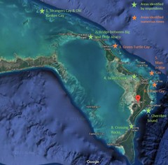
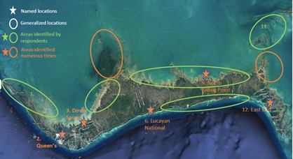
This consultation work allowed to identify priority sites for mangrove restoration in Abaco and Grand Bahama, respectively 8 and 7 (Figures 2 and 3)
Ecological Assessments: Mangrove Mapping
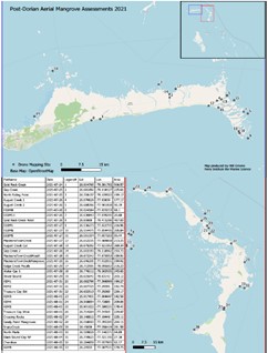
PIMS mapped a total of 34 mangrove areas for Grand Bahama (19) and Abaco (15), for a total of nearly 6,700 acres mapped, with individual sites ranging in size from 27-506 acres (Figure 4).
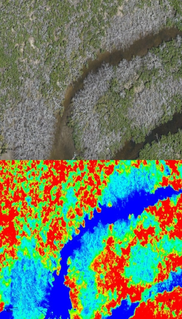
Mangrove habitats were assessed and mapped using advanced drone technology (both a 45 MP camera and a 10-band multispectral sensor mounted on a commercial drone flown at 400’) to create a baseline assessment. The resolution of the NDVI multispectral imagery allowed to produce better habitat maps and gain a more comprehensive understanding of where Hurricane Dorian had the greatest impact to mangroves, how mangrove systems have been impaired or destroyed, and where natural recruitment or recovery may be occurring. It also allowed to identify any remaining healthy populations of mangroves and potential sources of mangrove propagules for use in replanting efforts (Figure 5).
PIMS conducted a quantitative analysis of mangrove habitats and focused on more detailed calculations of the amount and/or percent of mangrove habitat affected as a function of storm conditions and other factors. This analysis served as baseline for assessments of mangrove recovery.
Using available data from the in-water surveys, aerial surveys, and access to improved satellite data, PIMS developed a ranking system to prioritize restoration efforts in the locations that received the highest levels of mangrove loss and show low levels of natural resilience, as well as those of other intrinsic value. Prioritization was based on quantitative data collected during the assessments and satellite imagery and applied a ranking system for specific indices to select sites where the greatest restoration impact may be made. The ranking system was based on three indexes below and applied a stepwise manner to filter sites for consideration for restoration:
- Damage Index: this first index was based on the extent to which mangroves were lost in an area, using NDVI values. NDVI values the status and health of mangrove areas were determined before Dorian and compared with values of the same areas after Dorian. Priority areas for restoration will include those that had the greatest negative change in NDVI values, which tended to be mangrove areas with high canopy density before Dorian that show little to no living canopy after Dorian. For restoration efforts, only high to highest priority sites (red-orange) were considered for mangrove replanting, but other restoration interventions may be considered if value ranking scores are high. A GIS map of the Damage Index can be viewed using the link below: https://pims.maps.arcgis.com/apps/webappviewer/index.html?id=753cdacb9ea64d7e84ededbf99852e08
- Resilience Index – For sites where the Damage index is ranked as high or highest priority, a second, the Resilience Index, was calculated to prioritize restoration efforts. This resilience index examines the extent to which dead mangrove areas are recovering, primarily through the new mangrove recruits from propagules, but may also include new shoots from mangroves that were heavily damaged by Dorian but are starting to recover. This index was based on the number of recruits per acre/hectare calculated using aerial imagery with high resolution cameras and multispectral sensors on a drone,
- Value Index – Finally, this index was applied independently to all sites, regardless of whether the other two indices indicated a need for replanting. For sites that were high or highest priority for replanting based on the two previous metrics, the value index provided one more data point to rank the highest priority sites. For sites where replanting was not a high priority based on the two previous criteria, but other interventions may be recommended (e.g., hydrologic restoration, debris removal), this index identified highest priority sites to dedicate resources to interventions. The value index is a qualitative ranking based on the ecological function of mangroves, the ecosystem services they provide, and perceived value to local communities. Six binary metrics were included: social value, inclusion in parks & protected areas, Coastal protection, Mangrove height, Fish diversity and Fish biomass.
This ranking system helped identify the priority sites for replanting mangroves. This information led to the development of a comprehensive mangrove restoration strategy to conduct the most appropriate interventions and determine suitable restoration methods when mangrove replanting is determined to be necessary. The strategy was completed in November 2021.
Areas around East Grand Bahama and a few areas along the north shore of Grand Bahama had the most damage. On Abaco the damage index was high or highest, primarily on the west side of Abaco in the Marls between Treasure Cay and Marsh Harbour.
Ecological Assessments: Fish and benthic communities
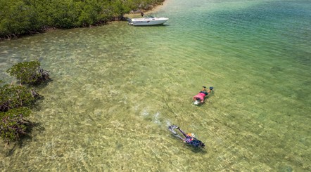
PIMS assessed fish assemblages and benthic habitats to detect changes in species communities caused by Hurricane Dorian throughout the mangrove system and help determine best approaches to rehabilitate or restore systems to pre-storm levels. In total 19 sites on Grand Bahama and 11 sites on Abaco were assessed. Data collected were compared to previous assessment done in 2019 before Hurricane Dorian and using the same survey method (30×2 m belt transects).
In general, assessment throughout the survey sites of both Grand Bahama and Abaco showed that fish communities did not change dramatically since Dorian (or were quick to recover) and did not vary with mangrove damage due to the fact that the root structure of dead mangroves remained largely intact and still served as habitats for fish (e. g. nursery). However, it was noted that dead mangrove roots were brittle and started to decompose, creating a risk for further degradation of the habitat for fish if left unrestored (Figure 6).
Quantitative analyses of fish and benthic data is needed to examine long-term changes in the mangrove systems and check whether restoration efforts influence positively fish and benthic communities.
Mangrove restoration effort
In late July 2022, PIMS received the necessary permits from the Bahamas Forestry Unit to commence restoration activities based on the mangrove restoration strategy developed in 2021
Restoration effort was conducted between August and September 2022 under this permit.
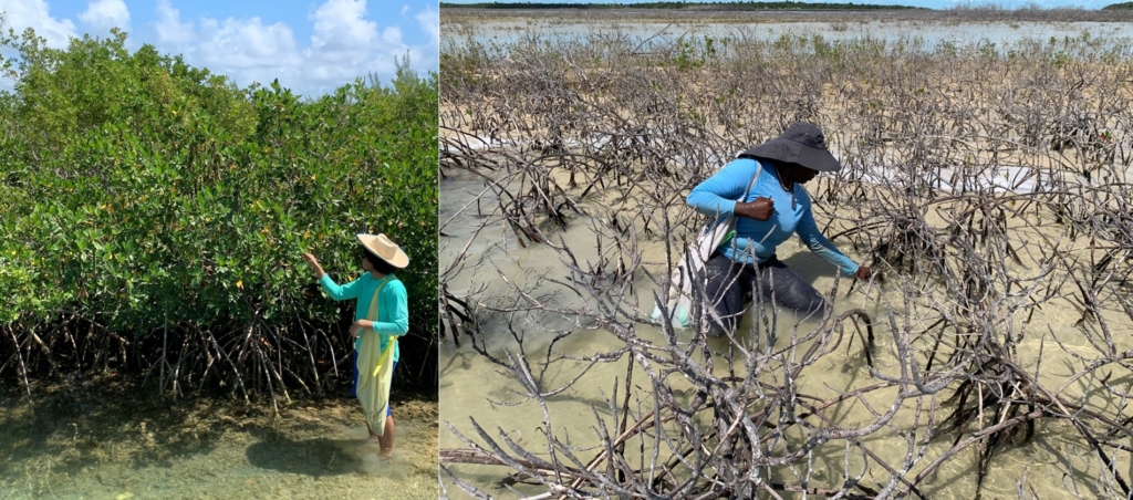
The restoration efforts consisted of collecting mangrove propagules from healthy red mangrove systems on both islands that saw little to no impact from Hurricane Dorian and then directly planting propagules in impacted areas. Both mangrove collection and planting efforts were conducted by PIMS and BNT staff as well as local volunteers who were trained onsite on best methods to conduct the restoration work.
A total of 20,408 propagules were collected with 12,500 propagules collected from Grand Bahama for planting there and 7,908 collected from Abaco for planting on Abaco. All propagules collected were tracked by their source site to ensure genetic diversity during subsequent planting. Mangrove planting occurred at sites identified as priorities on both islands that were accessible by boat (Figure 7)
Monitoring
Following mangrove planting, baseline data was collected from planting sites and control sites where natural recovery is being assessed for both Abaco and Grand Bahama. Data collection at this time included high resolution mapping of the site. Data collection from 35 sites on Grand Bahama and Abaco occurred in September 2022. This technology will allow to not only track the status of the site, but fate track individual mangroves (those regenerating, new natural recruits, and planted mangroves) to examine recovery; assess restoration success and determine what additional intervention will be needed. Data is currently being processed to:
- Determine the extent of natural recovery over 2021 for sites where previous imagery existed
- Track the survival rate or mangroves planted prior to July 2021
- Establish a baseline for examining the recovery of mangroves planted and dispersed during planting efforts in August 2022
Additional monitoring expeditions were planned after the project to assess mangrove recovery and examine changes in fish community structure and environmental parameters in order to evaluate the success of the restoration efforts.
Available documents and information:
- Final report of activities carried out between 2021 and 2022
- Mangrove Restoration Strategy– PIMS (2021)
- Little Bahama Bank Mangrove Restoration Sites (GIS platform) https://www.arcgis.com/apps/mapviewer/index.html?webmap=f9043c68b995452580c2c27e1028fa1c
- Mangrove Report Card of the Bahamas (2022)