
Refine data and measurements in priority areas
This task is being carried out by IFREMER, BRGM and extra-community partners (University of the West Indies Trinidad & Tobago, CARICOOS, MonaGis) and will refine the data in the priority measurement areas, duration and key parameters to be observed.
Measurement campaigns are planned in the French Antilles and in the islands of Extra- European partners.
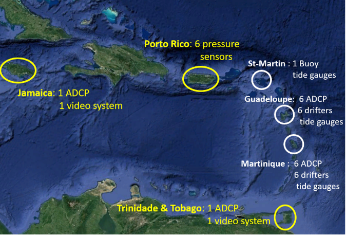
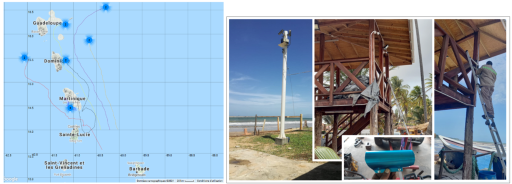
Numerous measurement campaigns have been carried out by the CaribCoast project partners, with the deployment of instruments such as ADCPs, pressure sensors, drifting buoys and video cameras. Some of this equipment, acquired in the framework of CaribCoast, was delivered to the extra-community partners of the project in order to reinforce their acquisition capacity. This concerns: the University of the West Indies in Trinidad & Tobago, CARICOOS in Puerto Rico and MonaGis in Jamaica. Other measurement campaigns, conducted by IFREMER and BRGM, with the contribution of NortekMed, have taken place near the French West Indies. In all, 14 ADCPs, 6 pressure sensors, 1 wave buoy and 2 cameras were installed at various sites and 12 drifting buoys were released (see figure).
Thank to this, we were able to collect a great deal of data on the studied sites, such as the speed, direction and variability of marine currents, water level, seabed temperature, wave characteristics and coastline evolution. These data enrich the understanding of physical phenomena related to coastal hydrodynamics and can be used to validate numerical models.
Some of the project data will soon be available for download from the project’s digital platform, where reports of the measurement campaigns and descriptions of the data collected can also be found.
Creation of a hydrodynamic modeling platform
A hydrodynamic modelling platform will be created to improve the knowledge of the 3D circulation of water masses in the region by detailing the role of eddy structures (< 30 km) in the control of hydrological properties in the vicinity of Caribbean islands taking into account the impact of extreme events such as hurricanes.
This work will be carried out using numerical modelling according to :
Two spatial scales of work: The Caribbean Sea and the French West Indies (Guadeloupe and Martinique);
Two time scales, reanalysis for the period 1980-2010 and projection for the period 2070-2100 to take into account the effects of climate change.
- Two spatial scales of work: The Caribbean Sea and the French West Indies (Guadeloupe and Martinique);
- Two time scales, reanalysis for the period 1980-2010 and projection for the period 2070-2100 to take into account the effects of climate change.
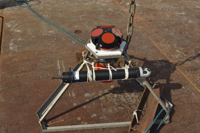
ADCP : Apparatus for measuring currents in the water column.
The hydrodynamic modelling activity carried out by the various project partners aims to feed a hydrodynamic modelling platform for the Caribbean. This platform aims to improve knowledge of: 3D circulation of water masses in the region, detailing the role of eddy structures (< 30 km) in controlling hydrological properties in the vicinity of the Caribbean islands; and to assess the exposure of coastal regions to the impact of extreme events such as cyclones and tsunamis.
This modelling work focused on the regional spatial scale of the Caribbean Sea, as well as on the more local scale of the French Antilles (Guadeloupe, Martinique and Saint-Martin), in the two time frames of the reanalysis (past and present climate) and of the climate projections for the end of the century (2070-2100), in order to take into account the effects of climate change.
In particular, the modelling work carried out is :
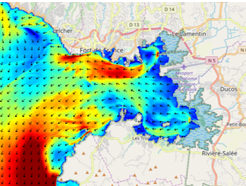
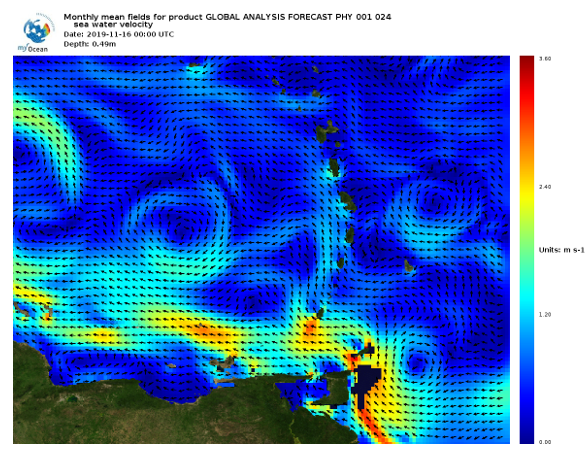
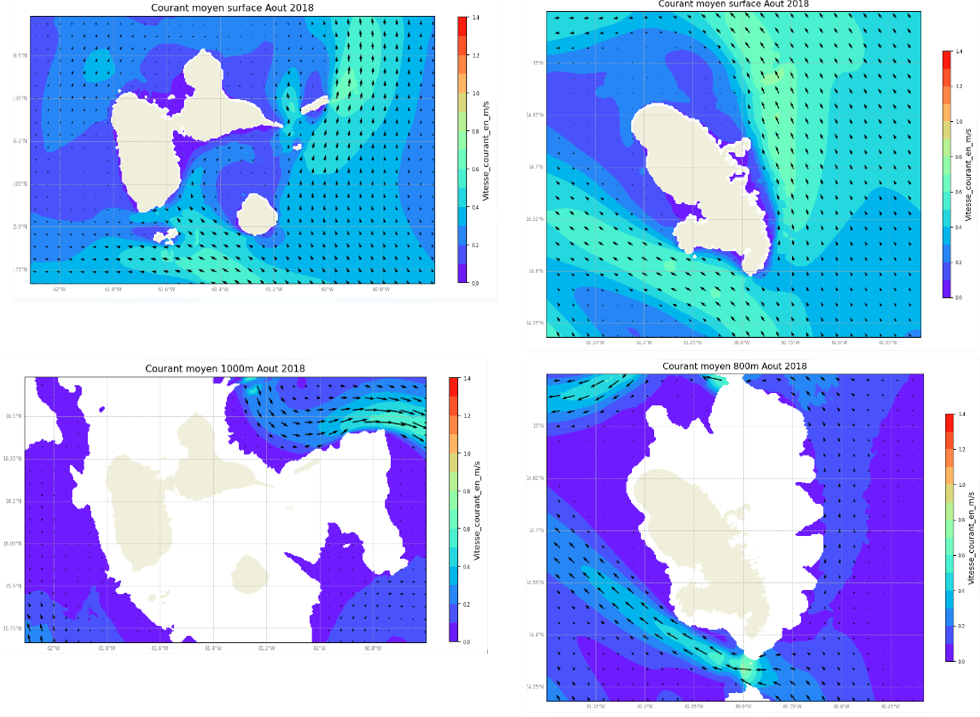
- IFREMER-ACTIMAR: the simulation of regional circulation and water quality around the islands of Martinique and Guadeloupe. 5 years of hindcast (2016-2020) have been computed using the MARS3D model. The produced data, available on the web platform and downloadable in NETCDF format, have a temporal resolution of 3 hours and a spatial resolution of 500m on a structured grid. The variables available are : 3D current speed and direction, temperature, salinity, sea level.
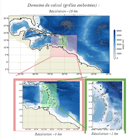
- LOCEAN : A hydrodynamic modelling platform using the NEMO code has been developed to improve the knowledge of the 3D circulation in the region, and in particular the role of eddy structures (<30 km) in the control of hydrological properties near the Caribbean islands. First, we developed a regional configuration at 10km resolution, to determine the sensitivity to atmospheric forcing over the last 10 years (DFS vs ERA5). We then refined the spatial resolution around the Lesser Antilles, down to 3km (red area in the figure bellow), to better represent the mesoscale processes in the archipelago, and compare the simulations with available observations. The variability spectra for the ocean currents are very similar to those from ADCP measurements, indicating that the local processes are well represented by this model. But individual events, such as sea level anomalies propagating from the south to the north, east of the archipelago, are not represented at the right time/place due to lack of data assimilation, and we struggle to identify the benefits of increasing the spatial resolution (other than representing the bathymetry around the islands more accurately). Finally, we produced simulations of future climate,circa 2100, to explore the impact of climate change on local hydrodynamic conditions. These projections, which have been produced with a regional ocean + atmosphere model of 25km resolution, are to be compared with their counterparts for the present climate. An ultimate configuration is currently under development, to bring resolution up to 1km around the archipelago (green area in the figure bellow).
The downloadable documents are the following:
- Highresolution hydrodynamic data (3km, 5-day sampling) for the Lesser Antilles Archipelago, for the year 2017: surface temperature, salinity and currents, sea level rise, temperature, salinity and currents at 100m depth
- Medium resolution hydrodynamic data (10km, 5-day sampling) for the Caribbean Sea, for the year 2017: surface temperature, salinity and currents, sea level rise, temperature, salinity and currents at 100m depth
- Low resolution hydrodynamic data (25km, monthly sampling) for the Caribbean Sea, for the periods 2001-2015 and 2086-2100 (according to RCP8.5 scenario)
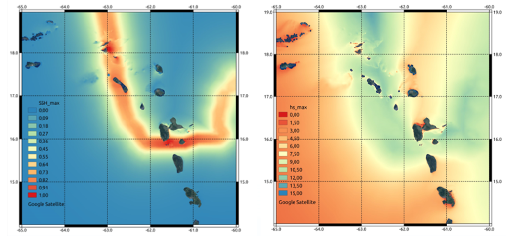
- BRGM : the estimation of waves and surges generated by the passage of cyclones, with calculation of the 100-year return period and joint probability, in present-day and future climate (horizon 2100). Among the hundreds of simulations carried out, the digital platform provides access to the most representative results, including some historical cases (Irma, Hugo, Dean, etc.) used for validation. Maps of the maximum values reached by waves and surges are also available, as well as maps of the 100-year return period for surge elevation, significant wave height, period and direction of the peak. It is also possible to extract the time signals of the variables indicated in the calculation domain, for the available scenarios.
- The assessment of water levels and arrival times for tsunamis. Hundreds of “worst-case” scenarios impacting the Caribbean were simulated considering different tsunami sources and rupture geometries. The set of scenarios allowed the creation of exposure maps, which show for each point of the coast, the most impacting scenario, the maximum water level reached and the arrival time. These maps are available on the web platform, with the data (in terms of water level) of the most impacting scenarios per sector.
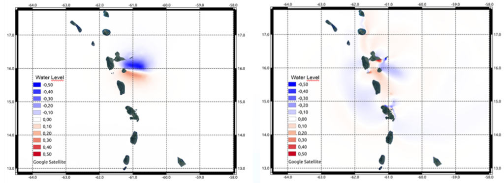
The simulations were carried out at the spatial scale of the Caribbean, using the UHAINA model, on an unstructured mesh with a coastline resolution varying between 300m (in the French Antilles) and 1km (Jamaica, Trinidad & Tobago, Puerto Rico).
An activity report was produced by each partner. It describes the details of the simulation work carried out and is available on the web platform.
For more information , click on the report on 3D water mass circulation modeling