
Background:
In 2014, the National Oceanic and Atmospheric Administration (NOAA) identified Culebra (Puerto Rico) as a critical Habitat Focus Area to address the growing challenge of coastal and marine habitat loss by integrating habitat conservation projects. High sediment loads threaten Culebra’s nearshore coastal habitats, and the source of the vast majority of these sediments is the dirt road network, as it lacks proper management practices. Erosion of unpaved roads in Culebra contributes to nearly 400 metric tons of sediment delivery to the coast per year and impacting surrounding coastal ecosystems.
Seagrass beds, coral reefs and associated ecosystems of Culebra provide habitat and/or feeding grounds for over 17 federally listed species, including green and hawksbill sea turtles and all seven Endangered Species Act (ESA) listed Caribbean corals.
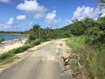
Since 2013, Protectores de Cuencas (PDC) has implemented land-based sources of pollution (LBSP) management practices towards the stabilization of over 28 miles of unpaved roads in Culebra. In addition to the chronic effect that roads can represent in delivering sediments to Culebra’s waters, extreme events like hurricanes can expose these ecosystems to degraded water conditions for an extended time period (Figure 1)
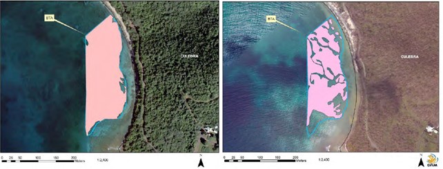
Hurricanes Irma and Maria passed through Puerto Rico in 2017 and caused substantial damage to seagrass, coral reefs, and mangroves. Afterwards, a seagrass assessment was conducted throughout Culebra to quantify the magnitude and spatial extent of impacts on seagrass communities due to the hurricanes. This assessment included seagrass habitat in Tamarindo, as well as seagrasses in adjacent areas. A GIS analysis was used to look at the spatial extension before and after hurricane impacts, and after-hurricanes ground truthing was conducted by sampling seagrass ecological condition. In Tamarindo, seagrass spatial extension declined by 27.6% between 2010 and 2017 (Figure 2).
Objectives :
The goal of this pilot project is protecting and conserving seagrass habitat in Tamarindo Beach by reducing current threats due to land-based sources of pollution (LBSP) and erosion which cause sediment and nutrient loads to reach nearshore seagrass and coral reef ecosystems.
PDC implemented a variety of best management practices (BMPs) to address LBSP and to improve nearshore water quality for seagrass habitat.
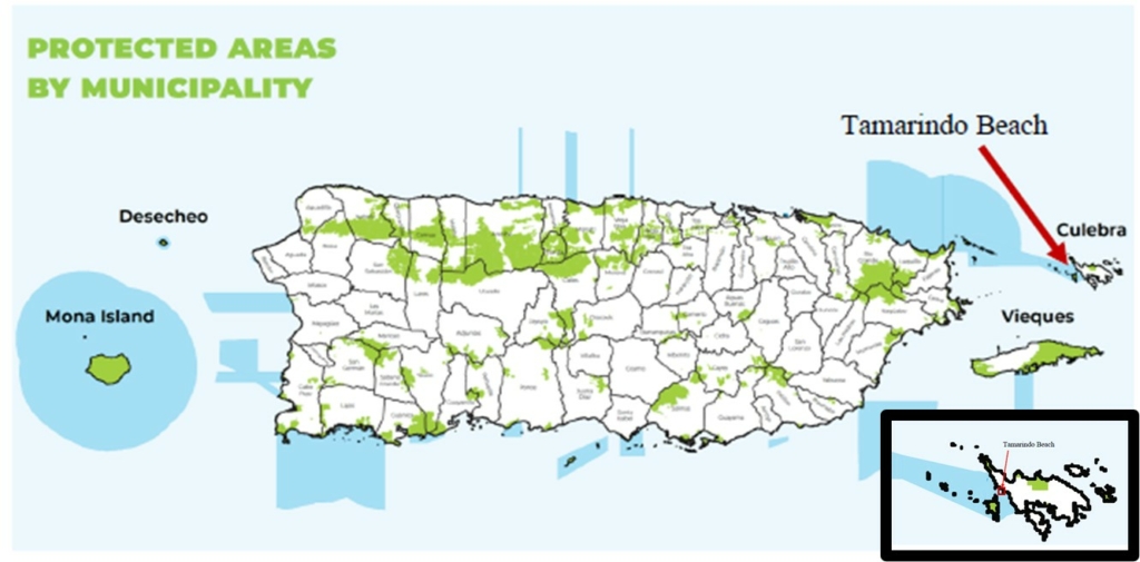
The project site is located in the marine reserve Canal Luis Peña, nearshore areas of Tamarindo Beach, Culebra Island to the east of mainland Puerto Rico (Figures 3). It focused on the seagrass habitats directly west of the Tamarindo beach. The proposed project, detailed below, was implemented in a 12-month period (August 2021-August 2022) by PDC.
This project complemented a current effort in project design and permitting, which were the first steps towards implementing BMPs in Tamarindo Beach. Funding from the Puerto Rico Department of Natural and Environmental Resources (DNER) was used for PDC to hold a kick-off meeting with key stakeholders to discuss the project, to complete the project design, and to acquire all permits needed for environmental compliance. Funding from Carib-Coast provided the necessary means for the next phase of the project, which was the implementation of BMPs and coastal restoration.
Main results:
PDC developed a project design of the site to be restored that included the areas where vegetative barriers had to be created and the location and specifications of best management practices that had to be used to reduce land-based sources of pollution entering the nearshore seagrass beds in Tamarindo Beach. The project design can be found in Appendix I of the report.
IMPLEMENTATION OF BMPs
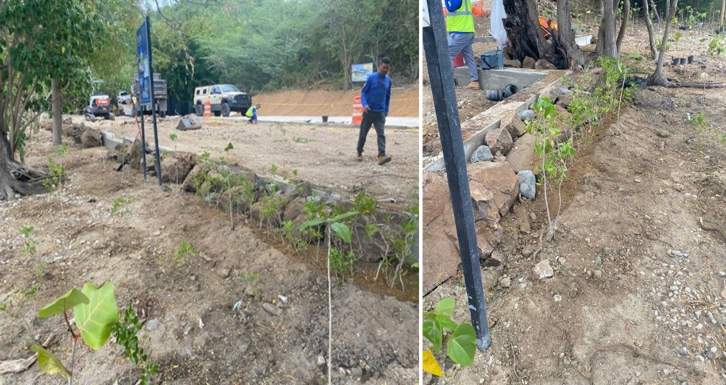
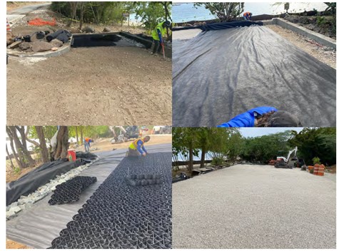
PDC purchased the materials and completed the implementation of the best management practices at Tamarindo Beach. The Municipality of Culebra closed down Tamarindo Beach, so that PDC could complete the stabilisation of the Tamarindo Beach paved access road, the stabilisation of the permeable parking lot area, the delineation of public access areas, installation of boardwalks, and coastal habitat restoration. In total more than 760 m2 of backshore area were restored with ecological engineering solutions to reduce heavy run-off in coastal waters and coastal erosion.
Coastal habitat restoration:
Three native species were chosen for reforestation in the coastal zone: buttonwood mangrove (Conocarpus erectus), portia tree (Thespesia populnea), and seagrape (Coccoloba uvifera). Additionally, vetiver grass was used since it has a dense root system for nutrient absorption and soil stabilization, can live in high salinity level soils, and it requires minimal maintenance. The DNER and the US Department of Agriculture Natural Resources Conservation Service have approved the use of this plant.
PDC planted a total of 650 individual plants from the following species: Conocarpus erectus, Coccoloba uvifera, Cordia rickseckeri, Tabebuia heterophylla, Thespessia populnea, Terminalia catappa, and Guaiacum officinale (Figure 4).
Paved access road and permeable parking lot:
PDC and partners used the project design to stabilize the Tamarindo Beach access road and to create the permeable parking lot (Figure 5).
A kayak staging area was included in the design. The DNER limited the number of businesses that can rent out kayaks and snorkel gear used in the area because it is a Marine Protected Area and because the excessive number of people renting out gear took up large parts of the beach and prevented the public from using the beach freely. The Community Advisory Board for the Collaborative Management of the Canal Luis Peña Natural Reserve pushed for the rental business to move to one area instead of spreading out across the beach.
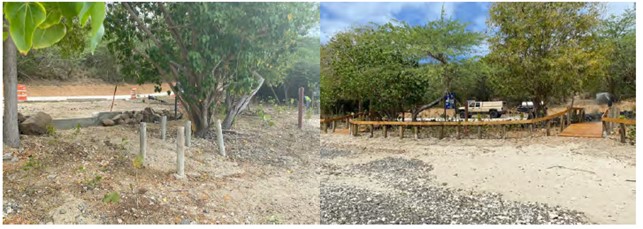
Delineation of public access areas:
PDC installed new wooden posts (previously damaged) and boardwalks to guide pedestrians to the beach without disrupting existing and newly planted coastal habitat (Figure 6)
Follow-up visits to ensure proper maintenance and evaluate functionality:
PDC has been conducting follow-up visits for irrigation and maintenance of the BMPs (Figure 7).
All implemented BMPs, including the permeable parking lot, the wooden boardwalks, the paved access road, and the delineation using the wooden posts and boulders are functioning as intended.
PDC has observed visitors in the area using the parking as appropriate and not stepping on coastal vegetation and are instead using the boardwalks to enter the beach.
ECOLOGICAL STUDY OF TAMARINDO SEAGRASS BEDS
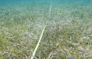
PDC conducted an ecological study in June 2022 to evaluate the nearshore seagrass bed condition in front of the Tamarindo Beach area, including the associated marine organisms (macroalgea, sponges, invertebrates and fish species).
The methodology used was the Braun-Blanquet Survey (Figure 7), developed to assess seagrass and macroalge abundance, using underwater transects. This survey was completed with quadrats to identify seagrass species and estimate their coverage. Afterwards, a roving diver survey within the seagrass bed and bordering coral reef was conducted to identify any additional species of seagrass, fish, or invertebrates in the area, as well as additional threats to the seagrass bed.
Key findings :
- Seagrass: Overall, the seagrass bed at Tamarindo beach appeared to be in healthy conditions and was dominated by Thalassia testudinum, followed by Syringodium filiforme, but with presence of the seagrass Halophila stipulacea. The first two species are native in Puerto Rico, while the third is an invasive species, known to displace the native seagrass species.
- Fishes and Invertebrates: Tamarindo’s seagrass ecosystem acts as a nursery for juvenile reef fish species (including commercial species) as well as feeding grounds for fish and Green sea turtle ( Chelonia mydas)
- Threats: During this project’s surveys, low amounts of sedimentation was noted on some seagrass, which did not appear to be at the same extent of what was reported in 2018 (Hernández-Delgado et al. (2018)). Bare sandy patches were noted and indicated a disturbance to the seagrass bed by external sources (e.g. effects of hurricane damage, anchoring, recreational use, and debris, among other reasons). These disturbances are opportunities for the invasive H. stipulacea toextend its coverage and compete with native species, thus the importance of reducing disturbance that causes mechanical damage to the seagrass beds.
Preliminary results seem to indicate an increase of water quality and reduction of sediment loads in the seagrass bed, but further long-term monitoring is required to show the positive effects of interventions to better manage land-based sources pollution and seagrass bed restoration.
Available documents and information:
- Final report of the activities carried out between 2021 and 2022
- Hernández-Delgado et al., 2018: https://www.drna.pr.gov/wp-content/uploads/2018/06/Culebras-seagrass-assessment-after-hurricane-Maria-SAM-compressed.pdf